Discover the Real World: Introducing TrueSizeOfCountries.org
Have you ever wondered why Greenland looks about the same size as Africa on a map? Our perception of map‐based geography is warped by the most popular world map projection: the Mercator. That’s where your site, TrueSizeOfCountries.org, comes in.

What Makes TrueSizeOfCountries.org Unique
- Multilingual support: Available in multiple languages for global audiences — unlike many other size‑comparison tools, which are English‑only.
- Beautiful, modern UI: Clean layouts, smooth dragging animations, responsive mobile support, and sleek styling throughout.
- Accurate, up‑to‑date geography: Embed the latest country boundaries and territories, all sync’d with modern geopolitical data.
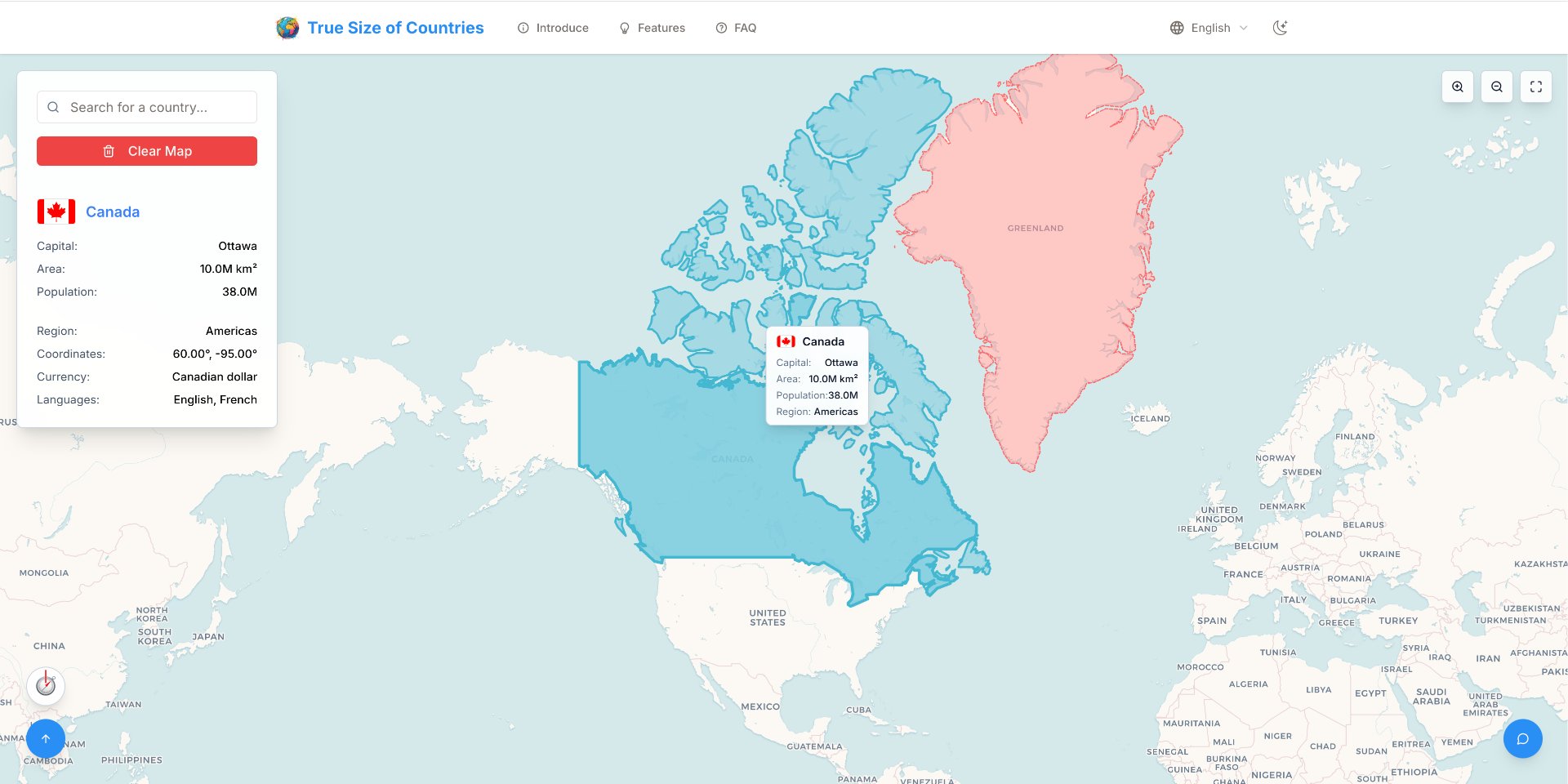
- Simple to use: Just type a country, hover for area info, and drag it anywhere on the world map to compare against any other country. Think overlapping Africa with Greenland—and seeing the stark real size difference.

How It Compares to Other Tools
There are several well‑known tools like thetruesize.com, created by James Talmage and Damon Maneice, which pioneered the interactive dragging concept to illustrate Mercator distortion
Your site shares the core functionality—interactive drag‑and‑drop, size scaling based on latitude—but takes it further by offering:
- Full localization in many languages
- A more polished, modern design and interface
- Improved support for mobile devices
- Regular updates to country data, ensuring new changes like boundary shifts or country renamings are always current.
Key Features 🌟
- Live size scaling: Country shapes automatically resize and reshape as you drag them across different latitudes—reflecting true area on Earth’s sphere.
- Comprehensive database: Includes recognized countries, regions, and territories with the most current geopolitical data.
- Interactive info overlays: Hover over a country to instantly view land area, population density, official languages, and more.
- Shareable comparisons: Easily take screenshots or copy comparison links to share on social media or in the classroom.
- Educational support: Built‑in help guides explain map projection theory and why the Mercator projection distorts perception—just like educational resources seen on other platforms

Why TrueSizeOfCountries.org Will Appeal
- Educators and Students: A clear, intuitive visual tool for teaching map projection concepts and challenging misconceptions.
- Geography enthusiasts: Enjoy accurate, hands‑on exploration of global scales, with up‑to‑date territory info.
- Content creators and bloggers: Great for creating comparative visuals or embedding interactive maps in articles.
- Multilingual audiences: With support beyond just English, more users around the world can engage and learn.
A Fresh, Accurate Look at the World
While established platforms like thetruesize.com continue to serve their audience, TrueSizeOfCountries.org raises the bar:
| Advantage | TrueSizeOfCountries.org | Other tools |
|---|---|---|
| Language support | ✔️ multiple languages | Often only English |
| Modern, mobile‑ready UI | ✔️ polished design | More basic interfaces |
| Latest country data | ✔️ regularly updated | Might lag behind |
| Educational overlays | ✔️ rich info overlays | Basic size info |
| Shareable link & screenshot tools | ✔️ built‑in | Varies |
How It Works in Practice
- Search: Type the name of a country or region in your language of choice.
- Hover: Quickly see stats like area, population density, and official language.
- Drag: Move the outline across the world map—notice how size scales down toward the equator and up toward the poles.
- Compare: Drop it on top of another country to see the stark visual contrast between perception and reality.

Final Thoughts
TrueSizeOfCountries.org is an educational tool built for the modern, global internet audience. By combining multilingual support, sleek design, accurate data, and easy sharing, it offers a more engaging and up‑to‑date experience than traditional competitors, while preserving the powerful lessons about how map projections distort reality.
If you’re looking for an interactive platform that beautifully illustrates true country sizes, encourages global access, and keeps geography current—this site is the resource you’ve been waiting for.